| Province/City | Capital | Area (km²) | Population | Density (/km²) | % Urban | HDI | Region |
| Dien Bien province | Điện Biên Phủ | 9,562.5 | 490,306 | 51.3 | 15.0 | 545 | Northwestern |
Natural area: 9,562.9 km2.
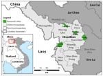
Dien Bien is a mountainous border province in the northwestern region of the country with geographical coordinates of 20°54'- 22°33' north latitude and 102°10'- 103°36' east longitude. Located 504 km from Hanoi to the West, the East and Northeast border Son La province, the North borders Lai Chau province, the Northwest borders Yunnan province (China), the West and the South West border the Lao People's Democratic Republic. It is the only province sharing a border with two countries Laos and China with a length of more than 455 km, of which: The border line adjacent to Laos is 414,712 km and to China it is 40.86 km. There are roads to Northern provinces of Laos and Yunnan province of China and air routes from Dien Bien Phu to Hanoi and Hai Phong city with an average flight frequency of 2 flights per day.
- Dien Bien province, in vietnamese " Tỉnh Điện Biên"
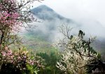
- Dien Bien Topography :

Pha Din Pass
Due to the influence of tectonic activities, Dien Bien's topography is very complicated, which consists mainly of steep, rugged and strongly divided hills. It is composed of mountains running in the Northwest - Southeast direction with altitudes ranging from 200m to more than 1,800m. The terrain is lower from north to south and gradually slopes from west to east. In the North, there are high points up to 1,085m, 1,162 m and 1,856 m (belonging to Muong Nhe district), the highest point is Pu Den Dinh with the height of 1,886m.
In the West, there are high points up to 1,127m, 1,649m, 1,860m and high point range from Muong Phang dragging down to Tuan Giao. The narrow and steep valleys and rivers are mixed with high mountains. In particular, there is a remarkable valley of Muong Thanh with the width of more than 150km2, which is the largest and most famous field of the province and the entire Northwest. The mountain was strongly eroded, creating quite wide plateaus such as A Pa Chai plateau (Muong Nhe district), Ta Phinh plateau (Tua Chua district). There are also terrain types of valleys, rivers, alluvial terraces, detrital cone, colluvium, karst caves..., which are widely distributed in the area with a small area.
- Climate:
Dien Bien province has high mountainous monsoon tropical climate. Winter is relatively cold with little rain; summer is hot and rainy. Weather is influenced by hot and dry westerly winds. The annual average temperature is from 21°C - 23°C, the lowest average temperature is usually in December of this year to February next year (from 14°C - 18°C), the months with the highest average temperature are from April to September (25oC) ). The average annual rainfall is from 1500 mm to 2500 mm and is often seasonal. The dry season lasts from October of this year to April next year. Annual average humidity is from 76 - 84%. The average number of sunshine hours ranges from 158 to 187 hours per year; months with low sunshine hours are June and July; months with high sunshine hours are usually March, April, August and September.
Dien Bien has high mountainous monsoon tropical climate. Winter is relatively cold with little rain; summer is hot and rainy with erratic performance characteristics, diverse differentiation, influenced by hot and dry westerly winds. The average annual temperature is from 21oC - 23oC, the lowest average temperature is usually in December this year to February next year (from 14 oC - 18 oC), the months with the highest average temperature are from April to September (25 oC). However, it only occurs in areas with elevation less than 500m. The average annual rainfall is from 1,300-2,000mm and is often seasonal. The dry season lasts from October this year to April next year. Annual average humidity is from 76 - 84%. The average number of sunshine hours ranges from 158 to 187 hours per year; months with low sunshine hours are June and July; months with high sunshine hours are usually March, April, August and September.
- Population:
The average population in Dien Bien province in 2019 was estimated at 601,659 persons, an increase of 11,141 persons, equivalent to 1.89% compared to 2018, of which: Urban population was 86,555 persons, accounting for 14.39%; rural population was 515,104 persons, accounting for 85.61%; the male population was 305,005 persons, share of 50.69% and female population was 296,654 persons, share of 49.31%.
- Natural resources:
Forest
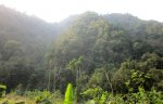
Currently, the province has 350,854.79 hectares of forest, reaching a coverage rate of over 37%. In the forest, there are many kinds of rare and precious wood with high economic value such as: Chukrasia, White Meranti, Iron-wood, Apitong, Fokienia... In addition, there are other specialty trees such as lacca wood, Calameae wood... Not only there are many types of rare plants, Dien Bien forest also has 61 species of mammals, 270 species of birds, 27 species of amphibians, 25 species of reptiles, 50 species of fish. In recent years, due to the burning and hunting of wild birds, the number of precious animals and birds in the forest has decreased, some species are in danger of extinction.
Mineral resources:
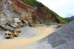
Dien Bien does not have many types of minerals; however, through preliminary investigation, province still has some main types of minerals such as coal, black stone, gold, sand, gravel and other construction materials... Currently, Thanh An bituminous coal mine has reserves of about 156,000 tons; the kaolin mine in Huoi Pha has reserves of about 51,000 tons; construction quarries in Tay Trang; mineral deposits in the upstream of Da river; Muong Luan mineral water... Although these mines have a small reserve, this is quite an important resource for the development of industries - handicraft in the locality.
River system and water resources

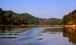
The water source in Dien Bien is very rich and plentiful with three major river systems passing through the province, which are the Da River, the Ma River and the Mekong River. Rivers in the province often have slopes with many waterfalls and rapids - especially rivers in the Da river system and Nam Rom river; therefore, there is potential for hydropower development. Water quality is relatively high and less polluted.
Song Da in Dien Bien has five main tributaries: Nam Ma, Nam Bum, Nam Po, Nam Phap and Nam Muoi. The total area of basins is about 5,300 km², accounting for 55% of the natural area of the province. The Da River flows through Muong Nhe, Muong Cha, Tua Chua, Tuan Giao districts and Muong Lay town.
As for Ma river, there are two main tributaries: Nam Hua river and Lu stream. The total area of basins is 2550 km² and it is the second largest river system of the province.
Mekong River system has a basin area of less than 1650 km² with the two main tributaries of Nam Rom river and Nam Nua river. Nam Rom river originates from Dien Bien district through Dien Bien Phu city to Pa Thom (Dien Bien district) and then flows to Laos. Nam Nua river originates from Muong Nha in the direction from south to north, then changes from east to west and meets the Nam Rom river in Dien Bien Phu and then flows to Laos.
The whole province has more than 10 lakes and more than 1000 large and small rivers, streams, which are distributed relatively evenly. t is noteworthy that there are Pa Khoang lake, Hua Pe hot spring and Uva hot spring. The province's groundwater resources are concentrated mainly in large valleys such as Dien Bien, Tuan Giao and Tua Chua districts. Although there is a large reserve of groundwater, it has not come into operation and only some test drills are performed.
- Tourism
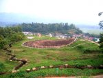
Dien Bien is a province rich in tourism potentials, especially in the cultural and historical field. The most prominent point is the system of Dien Bien Phu victorious historical relics including: Headquarters of Dien Bien Phu - Muong Phang campaign; Him Lam, Doc Lap and Ban Keo entrenched fortifications; A1, C1, D1, E1 hills and De Castries’ bunker.
Besides, there are many caves, mineral water sources and lakes forming a rich natural tourism resource such as: Muong Nhe primary forest; caves in Pa Thom (Dien Bien), Tham Pua (Tuan Giao); hot mineral springs in Hua Pe, U Va; Pa Khoang and Pe Luong lakes...
In addition, Dien Bien also has an intangible cultural potential with 19 ethnic groups living together. Each ethnic group has its own unique cultural nuances. Presently, the inherent customs and practices still remain, typically the Tai (Thái) and H'Mong (H' Mông) ethnic groups...